We are thrilled about the unveiling of our latest tool that automatically and independently creates a jQuery Interactive Map with custom divisions. In the past all maps with custom divisions required areas to be joined by our cartography team on the back-end. jQueryMaps would typically process these divisions based on a list of zip codes or counties in order to generate the divisions as part of a custom map. However managing the constant shifts in territories always posed a challenge and required for updates to come through us. Each revision would take a few days to process and deliver, which drew some reservations from clients. Our new custom tool addresses this requirement and allows for clients to fully generate and manage all custom territories directly on their servers within minutes.
How to update a jQuery Interactive Map with Custom Divisions
 Our breakthrough tool is powerful enough to create custom territory divisions based on groupings of thousands of sub-areas (such as zip codes), but is also simple enough for anyone to use. We wanted to provide you some details on the steps taken to create and update a typical sales rep territory map.
Updating the spreadsheet
Most sales rep territory maps are maintained on the back-end in an Excel spreadsheet or simple database table. The information essentially lists all of the sub-areas (commonly used sub-areas are census tracts, zip codes, counties or countries) and assigns each area to a region. For example, the spreadsheet would include the same territory ID for Canada, US and Mexico if these regions form part of North America. As the regions expand or contract, the IDs assigned to each sub-area change. Perhaps, Mexico shifts to form part of Central America or Canada is separated from the three. This is a simple example and in most sales territory maps, sub-divisions are far more detailed. Maintaining the updates in a spreadsheet is the most common approach for changing areas.
Updating through an Interactive Map
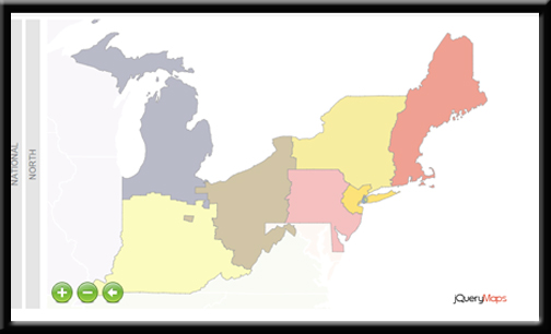
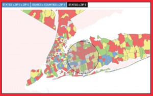
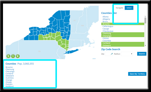 If maintaining the information in a spreadsheet is not preferred, we can also create a simple front-end map that shows all of the sub-divisions of the project color coded based on their associated territory. For example, all Counties in the northeast would be shown in the same color if they are part of the New England region. Management can then use this tool and a powerful area select feature, to highlight any areas that need to be changed and quickly edit the information. The changes would automatically be saved in the database and can be processed at the click of a button.
Multiple Levels and Navigation are Supported on Maps
 A major feature of our custom territory maps is the fact that they support multiple levels. Most companies separate their sales by regions and territories, although further divisions are also common. For example car dealers use multiple custom levels to define their sales regions within the US. An important aspect of our custom tool is that cartography can be processed and implemented for multiple levels, for example regions and territories, with a few easy clicks of a mouse. New levels can also be included in the project at a later date and integrated in the project easily.
.NET Page – Processing New Divisions:
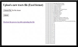 Once the territory updates have been applied in an Excel sheet or in the area selection tool described above, the information can be uploaded to run through an automated process to join areas. The system will merge all associated sub-regions into new polygons with all of the needed levels. Those polygons will be created as XML files, which can then be instantly displayed on our jQueryMaps. This process can handle multiple levels of custom divisions. The time required to run the process may take a few minutes depending on the total number of sub-divisions and jQueryMaps will setup an alert system to notify administrators once the XML files have been generated and saved to the map automatically.
STEPS: The process to update territories can be achieved in just minutes:
- Apply changes to custom divisions
- Depending on how you are saving your territories, update your Excel spreadsheet or database table directly.
- OR, use our admin tool to select and assign sub-divisions through a visual map interface.
- Upload the latest updates to a .NET page that will run a series of algorithms on the back end to join sub-divisions and create custom regions.
- The system automatically stores the XML files with the new cartography in the map directory substituting the previous version. Next time you access the map you will view the latest updates to the project.
See how jQuery Interactive Territory Maps can be Designed for You!
You may wonder how a jQuery Interactive Map with custom divisions has been used in your industry. Perhaps you are currently using a map that requires for you to manually update the information on a monthly or quarterly basis. You might be interested in reading two examples below describing how this tool has been employed by other companies.
Forms+Surfaces: Company designs elegant architectural products for use in public places. The company contacted jQueryMaps to create a map that shows sales territory divisions, with a custom feature to select areas for analysis and future updates. The area selection tool is highly intuitive and will be used by management to select areas, whether territories or zip codes, and pull corresponding sales information from the database. An additional component of the project is an update features which allows for management to update territory divisions. The map is also used as the interface to assign Counties and Zip Codes to territories. Once selected and saved, users can run the automated process to generate a new cartography set in real-time. The overall tool is designed for users to view sales statistics, create reports based on specific areas and update territories as regions shift. See public example of their jQuery Interactive Map with custom territories.
Auto Dealers: A business solutions company, whose name is anonymous that partners with global corporations in the manufacturing, retail, telecom, technology, media and entertainment, banking, insurance, healthcare and public sectors. Their initial motivation for developing a custom tool came from a desire to move away from using the costly and time intensive software they were currently deploying to manually create custom divisions for an auto manufacturer in the US. The auto dealerships use groups of census tract divisions (which total in the thousands) to build their territories which consists of at least three layers of navigation. The current approach used by this company took many hours of work and thousands of dollars to license all of the software needed to achieve this task on a quarterly basis. jQueryMaps provided a custom tool which receives an Excel file, processes all of the census tract divisions and automatically unifies areas. The process was shortened from taking days to minutes and the one-time license approach offered by our company makes it straightforward and economical to purchase the application.
At jQueryMaps we are very excited about the launch of this new tool, which when paired with a custom admin, makes a simple task of managing even the most challenging sales territories. The sample principle of the tool can be applied to handling simple divisions, such as joining States or Countries to form regions, or more complex tasks such as joining thousands of zip codes or census tracts. The end result is a powerful and sleek system that enables the end user to manage their own cartography with complete independence and reliability. Contact us for a free walk through of this product. We would be happy to share our thoughts for how it can be used for your particular project.
Share the post "Using a jQuery Interactive Map to Show Sales Rep Territories"