An important use of interactive web-based maps is to display rep territories for companies. Built on HTML5 code and JavaScript, the software is designed to create a map or multiple maps with specific contact information, as well as the ability to manage the information as regions shift and data changes. This flexibility is a core feature of the product that permits companies to run and maintain the maps entirely on their own, without monthly fees or ongoing technical maintenance requirements. Changing content on any level is a snap and can be conducted in minutes.
In this article we will be discussing these topics:
-
Design your Territory HTML5 Map
-
Linking Interactive Data and Information to your Territory Maps
-
Managing Updates to Data and Territories on your Map
Determine the Divisions that Best Define your Map Territories
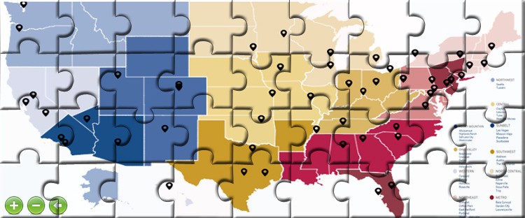
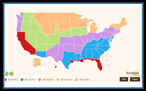
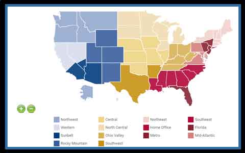 In many instances, determining the administrative territories that work best to create a map of your rep territories is a simple task. The data is usually organized by administrative area, linking a rep to a Country, State, County, Zip Code etc. In these cases, the type of cartography to use for the project is simply the lowest common denominator shared by all reps. Most of the projects we have had the pleasure of building work with State divisions or County divisions, such as the following example. However, there are some instances when divisions are more complicated. For some companies, assigning territories by Counties is sufficient for most of the US, but in highly populated areas, these divisions are further subdivided. This scenario is treated by creating a common top-level map of Counties for the project and exclusively adding sub-layers for all necessary regions of the Country. These sub-layers can include any number of administrative areas such as zip codes, census tracts, census blocks or neighborhoods. According to the lowest level of detail, any territory map can also be linked to OpenStreetMaps such as the following example. There can also be instances where territories are not defined by any existing administrative division and need to be assigned to the project visually based on an existing image. In this case, we can build a map based on an illustration or detailed instructions as was the case with the following client custom map.
Bring your Territory Map to Life with Interactive Data
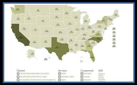
 The power and usefulness of interactive HTML5 maps is the ability to link the cartography to constantly evolving data. This enables the map to pull from a backend database or XML feed through a series of scripts that will be included with the purchase of any license. You have full control to change any of these scripts at any point in the future as all scripting code will be delivered. Image a map that is linked to your company central database and automatically detects changes in the reps or even rep activities. If updating the map were a manual process, it would quickly become quite tedious, however when automated, the changes are effortless as they only need to be applied once in your existing database to be displayed in the map and elsewhere in your website. This type of flexibility means that projects can become more complex and work with additional layers of information. The same map could potentially show rep territories when externally facing, but we coupled with data sales stats when accessed internally by management. You can now create a map with multiple functions. The amount of data that you can include with a map is truly limitless as pop-up boxes can resize automatically or be designed with a panel architecture to expand with sub-data. Any project can also include multiple tabs to display different types of data or combine datasets on the same map through a system of map filters.
Make a Map and Manage Territories Entirely on you Own
 In big part thanks to a new tool that was designed to create a map and manage territories with a merging software (see article), it is now possible for companies to update territories entirely on their own. The tool is part of an admin interface that includes a basic Excel upload option. Users can then access the admin, upload a new Excel sheet with updated divisions and run the merge tool to create the new areas on the map. This feature is a breakthrough for companies that need to update rep territories often or require for such tasks to be handled completely in-house. Within minutes, entirely new maps can be generated from simple Excel documents that anyone can manage internally within the company.
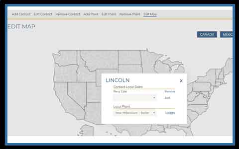 Even if merging areas to create territories is not a high priority, an admin tool is always useful to update content, such as contact info or product offering, through a non-technical interface. An admin tool is treated as an add-on to an interactive map and on a basic level allows for anyone with log in access to 1) add new information 2) edit existing information or 3) delete existing information. Since the data structure behind each project varies, no two admins are exactly alike. The tool needs to be tailored to interact with all of the database fields that would need to be changed to offer administrators with enough flexibility to manage updates on the map. See more about admins in our article. When you are creating a territory map for a business project, there are some underlying components that should be included with the admin. This would include the ability to identify lowest level areas on which the territories are built, such as States, Counties or Zip Codes and modify information for each. This step can be done through a map interface embedded in the admin or through a series of drop-down filters. This would give users the tools to select areas and change what rep each division belongs to. The second basic component is to include new reps to the project and edit information for existing reps. With these consideration covered, an admin tool would have the basic components for managers to edit content to the interactive maps, entirely in-house without IT requirements.
We always welcome your feedback and look forward to engaging to better understand you specific industry requirements for generating a custom territory map. Please contact us at your convenience with any questions you may have. We look forward to working together soon.
Share the post "Create a Map with Interactive Rep Territories for your Company"


