As summer is in full swing, many tourists are looking for excursions that provide a break from the routine while still averting large crowds. The appeal for nature-oriented travel has never been stronger and visitors to the US national parks are arriving in record droves. The enchantment includes the ageless appeal to connect with nature and the excitement of seeing animals in their natural habitats. Travelers also seek to expand their horizons by trying new hiking routes with the rewards of memorable views and the satisfaction of having achieved new goals. While taking on these adventures, either in the US national parks or throughout expansive conservation lands, the ability to reliably find and follow trail routes provides reassurance and enhances the experience of travelers venturing out into the wild. In many locations internet service can be sparse and following routes marked on traditional web-based maps is unreliable. The ability to locate the trailheads, along with reliable insights on the route, set the precursor to any successful outing. Working with Interactive Maps can enhance your next hiking excursion.
In this article we will look at the following topics:
-
Building Reliable and Responsive Maps
-
Enabling Interactive Features within your Software
Considerations when Contemplating Requirements for your Mapping Software
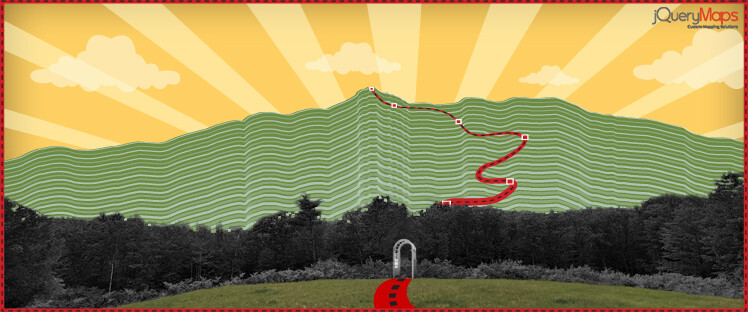
 Most custom mapping tools are created based on existing shapes or DXF layers. In some cases, the trail routes may already have been created using a vector GIS program which can be processed by our team and compiled to run with jQueryMaps. If needed, this task can also be completed externally and delivered to our cartography team at a later date, either by using a tool that captures the GPS coordinates of a path or by tracing the route over a background image that is true to its geospatial position. In both instances, the final files would provide the exact location of the route, which commonly is shown over a high-resolution topographic map background. The interactive maps features of the software can then be built into the system to allow for markers to be positioned along the route showing any number of features, ranging from the suggested views, shelters, or diversions along the hike. The accurate display of the route is just the beginning of the project, as the true value of the interactive map is the data added on the backend. If the project is created with an admin tool, subscribed users can easily upload content for approval which can then be accessed by the public.
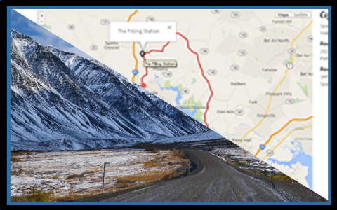
 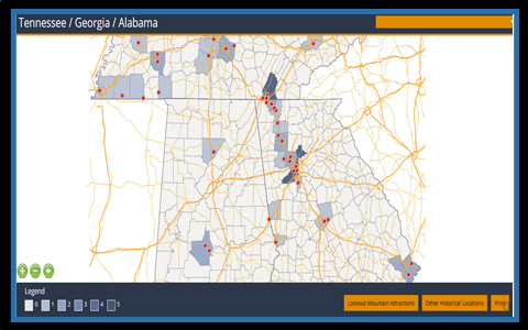 A first-hand account from a fellow hiker, with insights on a specific portion of a hike along with images, has incredible value to potential explorers. The dynamic content is shown through a system of layered pop-up boxes which are organized according to tab categories and assigned to a specific lat/lon value along the hike. Users can click on an icon and quickly navigate the categories listed along the top of the pop-up box until they select the content that they would like to view, whether it be the most recent images, hiker notes, or other information stored in the project and conveniently organized by date. The convenience of being able to easily confirm a fork in the path with visual contact that has been uploaded by other members and confirmed within the system is a quick reassurance to keep your excursion on track.
Offline Route Tracking Using Custom Maps
 The success of any outdoor application designed to work in a rural setting is the ability to run the software offline. In the case of hiking trails, this means that the interactive tool needs to have the option to easily download the hike and all associated content to the internal storage of the device in order for the information to be visible even when the mobile device is outside of cell phone range. A user would be able to select through an intuitive interface, the specific hikes or even sections of a hike (for longer trails) that should be downloaded, and the interactive contact, such as images, would be filtered to only include the most recent information. The result would provide the hiker with instant access to the full hike route on interactive maps, all available GIS information, and specific interactive content along the route such as uploaded images, notes, and approved observations. The layout of the interactive maps can also be printed from within the application and stored either as a PDF file or sent to an external printer. Following the same functionality, a hike, or even portions of the hike can be exported and shared with other users through email or social media. This can be a convenient method to prepare a hike amongst a team with real information from the ground on which decisions can be based. This can range from the most recent content on trail conditions, to the types of views one can expect to have along the way. This information can guide the planning of a trip in order to avoid unwanted surprises so that the focus of being outdoors is centered on the views and positive experiences.
Whatever the type of outdoor plan that you are considering this summer when embarking on a hiking adventure, the support of interactive maps can be both fun and beneficial. Having knowledge of real-time trail information through an interactive tool that is not solely based on internet access is an asset to all outdoor aficionados. Contact jQueryMaps for more information on your next mapping project.