Circle overlays might be the first definition that comes to mind when considering a zone. Often businesses, whether managing clients, deliveries or shipping, consider their zones in terms of mile radiuses. A business might feel comfortable providing deliveries within a 25 mile radius of their business, but not beyond or exclusivity for a franchise might include a 5 miles zone from an address. The ability to project these circles on a US States map is an important first step to analyzing business activity and assessing costs. When working with web-based maps, interactive overlays are especially powerful as additional content can be added to each overlay.
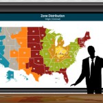
Examples of Why a Business Needs to Define its Zones
 Almost all brick and mortar businesses have a need to define and analyze their business territories. The specific types of territories and how they are assigned can be vastly different depending on the industry. See our recent blog article about building custom territories. In some instances territories can be linked to zip codes or county borders, but often zones are defined by a radius from an office, shipping center or any other central location. Defining a business zone through a States map or regional map is an important first step to determining potential customers, locating competition and seeing opportunities for growth. If nothing else, it provides a basic criteria by which to analyse one’s business activity.
Assessing Travel and Delivery costs
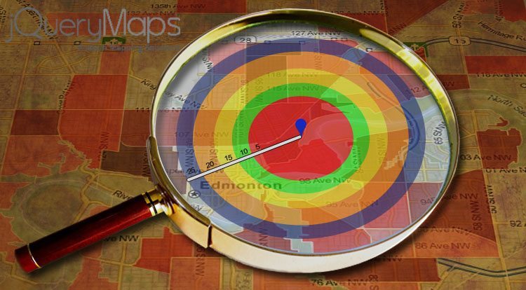
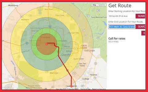 Companies that provide services to clients away from a central office, either through the shipping of a product or sending employees to a site, are primary candidates that would benefit from establishing zones. These zones can define a number of different aspects of the business, and the same zones don’t necessarily need to coincide. For example perspective sales zones might not be the same as shipping zones. Therefore different zones can be established on any States map to service specific purposes and zones can be toggled on and off through filters. For the sake of this blog discussion, the first purpose we will look at is a map to define zones based on travel costs for shipping and traveling employees. If a company provides maintenance services to clients, it is important to know what the fixed travel cost will be to send an employee onsite. This cost can be determined by creating a radius overlay that assigns zones either by mileage traveled or by linear distance. This important distinction comes into play in dense urban areas where crossing a short distance can take significantly longer based on complex driving routes. Overlays can be established by both driving distance and linear distance to meet different requirements. The same principle applies to delivery costs, which can be zoned and calculated based on either driving distance or linear distance between two points. The following examples (linear / driving), created for a limo services to show and calculate zones on a States map using Google Maps.
Business Markets
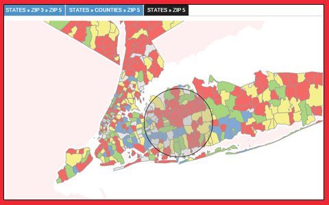
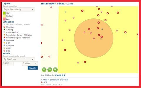
Overlays also play an important role when defining markets. The outline for a particular market can be established by a linear distance from a particular address, calculating all sub-divisions that fall within this area. For example, a business may say that their market includes all zip codes that fall within a 15 mile radius. The market can either be a single radius overlay that defines the reach of the company’s business activity, or multiple radius can be applied to establish varying zones, each with its own characteristics. 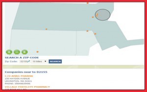 In this second scenario, zip codes within 15 miles may be primary business terrain, while outlining areas of 25 and 50 miles are still important, but less crucial for marketing efforts. These overlay circles can be drawn on any States map, including area-based zip code maps, county maps, OpenStreetMap or Google maps. Most important is the ability to link real-time data to these overlays. Hovering over a market can call a pop-up box with any data that you have linked to the area, including statistics on total marketing efforts, sales results, new leads information and much more. Overlays can also be displayed dynamically and different zones can be shown simultaneously. In some instances zones can be defined by a radius distance and projected as overlays, while at other times zones may be formed by non-circular groups of Counties. These variations are important to personalizing each market and multiple areas can be shown at once on any map. Contact us for any questions on how State maps and regional maps are used by business for analyzing business markets.
Business exclusivity, avoiding Competition
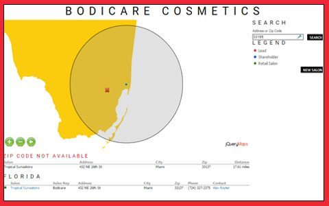 Another application for circle overlays is to define business territories in order to avoid conflicts between franchises or associated offices. While this task may appear straightforward, the equations to create the overlays can accept several different variables. This makes a States map with overlays highly flexible for adapting to specific regions and industries to provide different scale overlays and precise information. An example could be a franchise that is accepting new subscribers, but only will allow one subscriber within 5 miles of an existing location. Using a map lookup tool would be the obvious way to confirm whether potential locations are available or excluded due to conflicting territories. The easiest mechanism for searching an area is implement a zip code search or address search in a project. The result of either of these searches would display a cross-hair on the map and project an overlay circle along with an intersection if there are any conflicts with adjacent territories. This simple lookup tool provides a powerful resource for managers of any franchise to quickly locate conflicts in territories. A simple version of this lookup tool can be seen in the example States map with zip code search created for Bodicare Cosmetics. When working with dynamic maps, all of the components can be easily and immediately adjusted so changing the radius of any territory is a simple task.
Static vs Dynamic Overlays
One final item to address is the fact that overlays can be assigned to either a fixed item on the map, such as a business office location or shifting locations based on user filters. In either scenerio, ovelays can be integrated with the project and displayed on any States map.
 Static overlays can be displayed as fixed items on the cartography. In some cases this is necessary to clearly define where each office is located and the territory that corresponds to the location. Having the overlays displayed immediately avoids the task of requiring the user to click on the map or select a location in a filter. However these fixed overlays may also have some limitations in small areas if overlapping is not the desired result. While overlapping territories when displayed in semi-transparency is a great visual tool, the ability to selectively hide or show overlays provides a nice clear view for users. There are many ways for how the overlays can be activated and some of the most popular options are onclick event, hover over event, through a filter or when selecting a category outside of the map.
Every project and business is unique in how it defines its business territories. We recommend that you contact us for a free consultation to learn more about our custom solutions and how they can be applied to your industry. We look forward to hearing from you!
Share the post "Combining a States Map with Circle Overlays on Google Maps"