
A custom admin tool offers users an intuitive and non-technical method of managing data within a JavaScript Map project. As most map applications work with a database on the back end, the standard approach would be to interact with the data directly from within the database, hosted on the end-company servers, and usually accessible via ftp. However there are many cases where custom admin tools provide great solutions for both companies and general users of the map. Admin tools offer security, facilitate user interaction with the data and enable team participation without exposing any classified information on your servers. See how custom admins provide innumerable benefits for many jQueryMaps users.
Benefits of Using an Admin tool with an Interactive Map
We will try to describe the features of a typical admin and outline the main benefits that this solution provides. In general terms, an admin tool is a non-technical user interface that enables registered users to update and edit content on a dynamic map by applying changes to a database through an HTML page. We normally build the admin according to the type of data and table structure of your project, and as such no two admins are exactly alike. Below we will review the primary reasons our client request admin solutions to accompany their maps.
- Security for your Dynamic Maps
- Non-technical Solution for Managing Info on HTML5 Map
- Avoid Mistakes when Updating Dynamic Map Content
- Multiple User Interfaces for US or World Maps
- Admin Features and Highlights
 Our solutions are designed to run on a server and both the map and the backend database populating the project would be hosted on your company servers. This provides independence and peace of mind that all data is safely stored behind existing company firewalls currently in place on your servers. In this scenario, project content can be managed directly from within the database. In most cases a ftp path can be created to point to the database hosted on the company servers so that managers can access the tables and make changes to the map. The results of changes in the admin are instantly published within a JavaScript Map live map.
Security for your HTML5 Map
Direct ftp access poses a slight risk since permission is being granted to a user to make changes within a database on the server. While restrictions can be applied, large database can also control important aspects of the website and crucial company information. The effort of producing an external database just to populate the custom map is often undesired so companies are left with a decision on whether to grant editing access to employees managing the data. This can be a difficult decision to make with important consequences depending on the type of data being stored. An admin tool address this point since direct access is not provided and all changes are handled through the HTML fields built with the admin. This system provides more flexibility, without the risk for accidental data loss inherent with direct database editing.
JavaScript Map Editing via a Non-Technical Interface
 Company management using the custom mapping tool and perhaps editing content within the project, might not have the technical know-how to access, open and edit content within a database. While the steps are not complicated, in many circumstances it is preferable to create a tool that bypasses the technical aspects of managing the data behind the project, making the overall tool more user friendly and intuitive for company staff. Another important consideration is that not all employees can be granted the access required to directly open and edit the database running the interactive map, whether for server privilege reasons or privacy considering other content available within the database. The admin provides a tool to update and view only specific information, avoiding privacy breaches, technical restrictions and enhancement to the overall product ease of use.
Instant Updates to HTML5 Map Without Mistakes
Mistakes made within a database can be costly. This is especially true if the same database that drives the interactive map also connects other aspects of the website. For example, the sames statistics used to color code information on the map, might also be used in the end of the year balance calculations. Accidental deletion of data within the database tables can involve significant recouping efforts on the part of the company IT team.

An admin tool in this instance can be designed to only allow specific functions, such as entry of new data, but not deletion. Alternatively, deleting content can be restricted to individual users or stipulated to only allow single line deletions at a time. All of these safeguards are important to reducing the possibility for mistakes and accidental data loss. More frightening still is the possibility of accidental data loss through the deletion of full tables. When editing rights are granted to a team of people updating content in the database and map, these issues need to be considered. Using an admin tool to manage the database content immediately nulls these concerns as the amount of access for each user and the functions available can be limited.
jQuery Interface for Single or Multiple Map Users
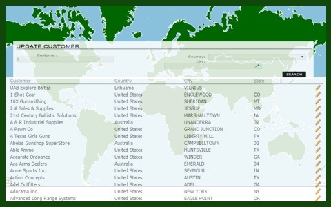
Accessing the an admin tool is much simpler than accessing a database directly. The admin tool is part of an HTML page and would only require internet access and a username and login. This means that among other benefits, the admin tool is geared toward multiple member contribution to the project and members can be located in the office or in the field.
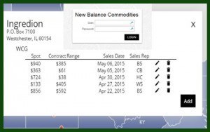 By integrating the admin within the pop-up box, prices can be immediately updated by any sales team member. The admin provides each sales member with a unique username so that the initials are stored along with all price updates. This enables the team to track who has contributed what sales prices are made to the interactive map.
Create and Maintain a Map with an Admin Tool
As mentioned above all admin tools are tailored to reflect the type of data included with the project and the requirements of the company for managing updates to the JavaScript map. As such, some features of the admin are unique to each project, however there are some common functionalities.
Editing Information Displayed on the Custom Map
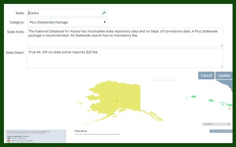
 The primary feature of the admin tool is to enable users to ADD, EDIT and DELETE content to the map. The content can be both area based, such as values for a State or County or location based, such as information for a particular city or office. The edit portion can be managed through fields as is commonly the case, or in some instances, through a pop-up box based on an area selected. This latter approach gives a more visual aspect to the admin rather than a tabular form, which for some data layouts is preferable, especially when dealing with territories and coverage areas.
Assigning Area Information for Territory Maps
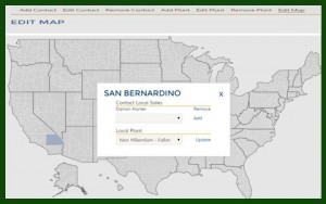
Another feature of the admin tool is to assign information to map areas. For example, a sales rep can be assigned to a new County or a sales value can be assigned to an office. The ability to both add and assign information is an important feature of the Admin tool. As described above, the process can be handled through fields and drop down boxes or through a visual map within the admin tool.
Plot and Position Icons on any Web Map
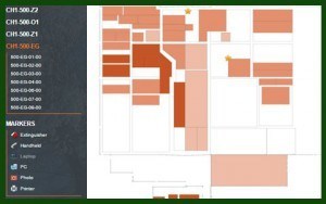 For all projects that include icons, the ability to plot information within the cartography is also an important asset of the admin tool. For AreaSelector maps, the positioning of locations is usually handled dynamically by geocoding a city, zip code or address to assign the lat-lon information that places the icon on the map. The admin can ask for a user to fill in the address information and the lat-lon is calculated automatically in a lookup. However for DynamicLocator projects used to map indoor spaces, the positioning of icons is based on an X Y coordinate. In this case, the admin tool can include a placement feature that can drag drop icons within a space on the map, such as placing computers within a room, information booths within a mall any other point within a custom map.
Main Types of Admins Used for Dynamic Maps
The primary purpose for developing a multiple tier admin is to accommodate several groups of people making changes to a project. While all users may be allowed to contribute content, the option to delete or modify entries might be delegated only to senior administrators. These access restrictions can be dictated by the username and password given to each user. Therefore senior administrators would have additional tools available to them within the admin, hidden from the general user. These types of multiple tier admins work very well for large companies that may want to delegate the data entry process to staff, but yet retain control over edits and deletions by select members of the team.
 Another important scenario where multiple tier admins are utilized is the case of self-managing websites that count on public content contributions. One example is the development done for MotoScope to manage new entries to the project using Google Maps roadways. Admins can also include a registration process that allows page members to sign up to add information to the website and map. The first step would be to create a simple page where a website viewer can type an email, username and temporary password. The page will then automatically store this information and send the user a confirmation email. Approving the user, along with all contribution made by this person, can either be instantaneous and automatic or pending a senior member’s approval. In any event, this process is important as it enables the general public to register and add content to a larger project.
In the example described above, it is also possible to allow for users to edit, but restrict this to only the listings that they have contributed. For example, a nice feature of the admin is to allow a user to later access their account and change the information listed in the map or add a new contributions to the page. In the MotoScope project above, a key feature was for the admin to limit content edits to only postings made by the registered user. These important safeguards are easily built into our custom admin tools.
Public vs Private Interfaces for a jQuery Map Admin
An extension of the conversation introduced in the previous point, is how private and public admins can work within the same project. A private admin is essentially a page that is not part of the front facing part of a website that is username and password protected. A member must access the page and then enter the admin with the correct credentials to access the editing portion of the tool. This type of admin is most common and designed for Company staff to update content to a project. Information once saved in the admin is usually configured to appear immediately in the live map.
 By contrast, public admins are designed to appear directly within the website alongside the JavaScript map, usually clearly accessible to encourage visitors to share content in the project. Depending on the nature of the project and the preference of the owner, information can then be displayed immediately or stored as pending approval. In the second case, any new posts will be made visible in a second tier admin for administrators to approve and post at the click of a button. This is a good method for encouraging public interaction with the map, while still retaining control over the tone of the content being posted.
The costs involved in preparing a custom admin to manage a JavaScript map will vary depending on the level of customization and complexity involved, for which reason, we usually recommend that clients contact us to provide more details on their project before generating an accurate quote. To provide readers with a general idea on prices, a very basic admin, considered to be an admin for a single username and password with the ability to add, update, remove 1-10 fields of information normally costs $695.00 to develop. The addition of additional layers, such as multi-tiered admins or custom interfaces that use a map to make selections, normally fall in the range of a more specialized tool approximately costing $1,945.00 All admin tools are unique in their structure and requirements, so please contact us for more specific information. We would also be delighted to share links and passwords to existing admin tools to review in a 20 minute free consultation.


One thought on “Drive your JavaScript Map with a Custom Admin Tool”