Building maps in HTML5 gives the possibility to create responsive mapping software to expand beyond just a single Country. A carefully designed World Map of Countries serves to define a business’s primary US presence, while also underlining its important international reach through offices, partnerships and agents. In order to take advantage of world maps, companies do not need to have locations in all Countries or even continents. World maps outline countries, but easily scale to focus on areas that specifically contain information. This important feature, empowers companies to display content for areas where they have a presence, while not drawing attention to unnecessary areas of the map.
In this article we will look at the following topics:
- Scaling your World Map of Countries and Continents [h3] park interactive
- Using Map Buttons for Smaller Scale Info (button for Country data in a pop-up centrifuge)
- Adding Informational Lines and Custom Data and Pop-Ups to a World Map
Reasons to Set Focus Levels on your HTML World Map
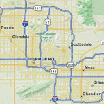
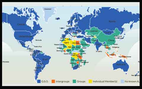 There are many instances where companies require using a World map, however, the data is located in specific regions. In this type of situation, having the default view of the map always display the entire World can make for a project that firstly may appear somewhat empty and also can distract users from what is the main goal of transmitting helpful information. The best solution for this common scenario is to first control the color by avoiding grayed out areas. It would be best to project the map with more homogenous colors and also set parameters so that any view centers on only Countries with active information. An example can be seen in the following World map of Countries once Europe is selected. Instead of centering on all Countries in Europe, the map automatically overrides the default zoom and shows only those Countries that have active information. This functionality can be done on any level and for any region of the World. Many projects that include cartography for Canada prefer to maximize the map view on the US and Southern Canada provinces where the information is centered. This can be seen here after selecting North America. While manual adjustments work to some degree, the real benefit of this feature is that the scaling of the map immediately adjusts as soon as new information is activated or inserted in the map.
For Limited World Map Data, Informational Buttons may Suffice
 World maps can include a wide array of coverage datasets. In some instances, projects may include data for all Countries in the World or even for sub-levels (such a States) within each Country. The reality is that this is usually the exception and most World maps include data for a select number of Countries. In cases where the data is especially scarce, it might not be beneficial to display a World map of Countries when the real content is concentrated in a select number of areas. To improve the user experience and enhance the company image, custom buttons can be integrated with any project. These buttons are displayed dynamically and can list multiple levels of information or a single pop-up box. For example, a US-based company with an office in Paris and London, may not want to show an entire World map on their page or even a European map with two locations activated. Since activity is mostly conducted in the US, the setup would focus initially on a US map with a button alongside the map that lists “European locations”. When selected, the same button then provides a second layer of information in a pop-up box listing the Countries where offices are found. This easy and intuitive configuration also allows for more information to be added to the same button or entirely new buttons on a project. When the information coverage grows sufficiently, the same buttons can be replaced by cartography of said regions of the world. This is a great tool for many growing Companies and projects.
The Custom Options Available for World Map Software
For some projects, the ability to color code continents, show markers and display world map names of countries is sufficient to use of the software. These standard projects provide smooth navigation between levels, a sleek look and feel and the ability to easily locate information for any area or marker displayed in the project. Yet, many projects also require custom development that is the core of our work at jQueryMaps. The ability to take a robust mapping software and build custom platforms to work with the map engine opens plenty of possibilities. We wanted to outline some of the features that have been created for recent clients.
Arched lines on World Map with Real-Time Data
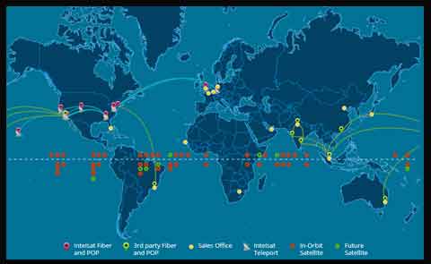 The first and most common tool is the use of arched lines to represent connections between markers. These connections have been used to show communication lines between servers as shown in the following World map example or to display airline routes within the US or internationally as displayed in this second example. The lines are not just static images and can be linked to dynamic information showing content for each of the connections. In the example of the airline routes, it would be possible to add details information for each of the routes, pulled from a database table, such as the frequency of flights, volume of flights and even real-time airplane positions and schedules. Lines have also been used to show delivery routes for many transportation companies, with the great advantage that all lines are displayed dynamically and can be easily changed, expanded or deleted with a simple database edit.
Custom Multi-Layered Pop-ups on World with Countries Projects
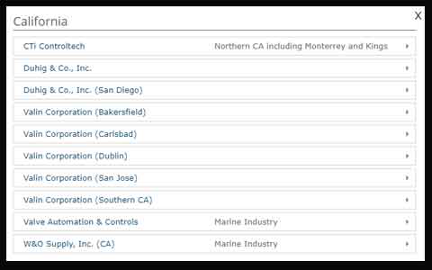
There are many instances where a one-level pop-up does not provide sufficient filtering of the data to accurately display the data associated with an area. For example, if there are multiple reps assigned to a Country, the contact information in the pop-up can become quite extensive. A better approach would be to implement a pop-up that has multiple layers and accordion style expandable content. See an example of dynamic content in World map pop-ups when clicking on the state of California.
The same approach can also be used to show detailed content for any area or marker of the map. When projects are used as an interface to filter extensive content, such as international policy or historical business data, the ability to dynamically expand content in a pop-up box is a great advantage.
Select Custom Icons & Filters on Website World Maps
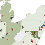
Many projects also require the ability to select areas and then store selections to use on a backend page. In the event of travel-related websites, perhaps subscribers are required to highlight countries where they have visited or would like to visit. World map of countries can be used to display data, but also to interact and save information to a backend database. This functionality is commonly used in client portals so that customers can define territories and coverage areas.
Another great feature is the ability to customize the entire look and feel of a project, including the area colors, background images, cursors, and pop-up boxes. For a look at this custom design and the options available, have a look at the following Custom US Map example.
Lastly, advanced content can be added to any project and displayed within the pop-up boxes. This can include but is certainly not limited to pdf images, sphere images, Google map street detail, links, videos or any internal content that can be called in the HTML of a page. One world map, shown here, with a particular display and some advanced contents was used for a satellite communication industry.
As discussed above, the scope and density of content on World map projects varies greatly. We have the tools to develop a highly specialized and custom designed solution for your company and industry. Contact us to learn more about our solutions.
Share the post "Expand your Digital Reach with a World Map of Countries"