Hospitals can be as varied as the patients that visit them. There are many benefits to a system of hospitals that provide individualized care, specializing in the type of treatment needed by patients. In a recent project, a US COUNTY MAP was applied to provide a geographic tool to display hospital locations and interact with dynamic data through a system of filters. The tool was created specifically for the North Carolina Hospital Association, however the same layout and general functionality can be expanded to other regions of the Country. Learn about the benefits interactive software can provide visitors.
In this article we will look at the following topics.
-
Benefits to Parsing Data and Displaying Results on a Dynamic Map
-
Features of a Personalized Mapping Tool for Hospitals
-
Custom Mapping with Eyes to the Future
Organizing Data Geographically using Interactive Maps is a Worthwhile Investment
 Information becomes a whole lot more powerful when it is linked to geographic data. By pairing hospital data with latitude and longitude information for each location, several possibilities become available. The locations can be plotted on a map in their real positions and linked to jQueryMaps software in addition to Google Satellite views. Another example of a project with Google Maps and USA States can be seen here. However, the real benefit is in the ability to activate filters to set ranges and display hospitals that align with specific criteria. Each project is different and these filters can be updated as needed for each map, but common options include filtering by hospital specialty, by particular doctor’s, insurance carriers or the number of beds. The information is immediately updated on the US County Map in real-time with essentially no lag to the user. This makes adjusting filters and sorting the results a simple task for any viewer of the project.
Consider What Options can be included in a Custom Online Map
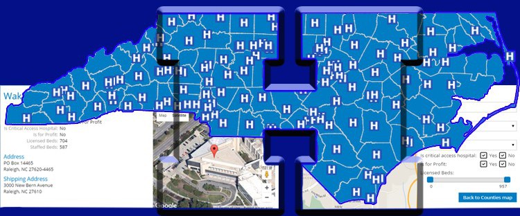
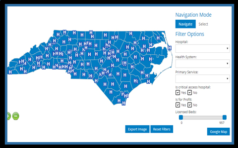
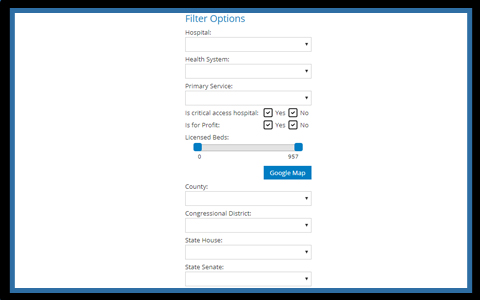 As suggested above, one of the main requirements when researching software is to choose a tool that is both flexible to use and also highly optimized to run on a web browser. This second point is imperative as mapping applications can easily become overloaded with high-resolution images that render the project slow when loading on a browser or from a tablet device. Therefore the tool should allow for easy data updates, whether in real-time or through an admin feature and for the results to be displayed instantly on the map. Most applications work with JSON data, XML files or information can also be pulled from any major database (such as MySQL, MS SQL, Oracle etc). Once the map software is configured to read an existing data source the next task is to create filters that will be useful for users of the application. In the case of the following US County Map project, the filters used are by hospital name, healthcare affiliation, primary service offered, whether for-profit and the number of beds available. This last filter was created on a sliding scale that shows the exact number selected. In the case of the particular project above, all of the information is loaded initially in JSON and subsequently hidden according to the filter selection. This increases the system response time as information only needs to be loaded initially into the map. Within the pop-up boxes, users can find content that includes address details, specific hospital data, and an embedded Google map focused on the specific location with satellite view.
Full Options available with US County Interactive Maps
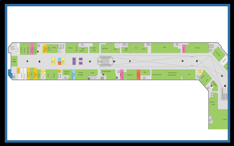 Other considerations when creating your project include expanding the levels of mapping and administration tools of the project. One potential resource is the DynamicLocator which is a robust tool designed for mapping interior spaces. This software can be integrated with a County Map loading floor plans for each hospital location when an icon is selected at the County level or even within the embedded Google map. The DynamicLocator can work with its own specific filters, offering the ability to locate specific wards or employees via a keyword search. This system can also connect with a database of services provided and internal scheduling to offer a tool to staff and management to increase day-to-day efficiency. The mapping of interior spaces is also discussed in other articles. A personalized admin tool is also an important consideration with your project as it provides a simple, non-technical interface for data entry to the project. The typical functions supported include adding new locations, editing hospital information or deleting hospitals altogether from the program. The admin tool can also be taken a step further for staff to upload new content within a pop-up box, such as patient release and check-in or request for more equipment. All actions performed within the admin are stored to a database and can be configured to link to external sources such as CMS, email servers or other company managing systems.
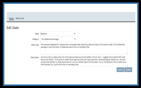
US County Maps combined with hospital information and geodata form a great tool for users. The public can benefit from these custom maps to search for specific locations, apply filters and interact with the data through a simple to use platform. Data entry and management can be enhanced using admin tools that tie into existing database tables and serve as methods for editing content, generating reports and creating new filters. Contact us for more information on implementing dynamic maps for your company.