We would like to wish all of our friends and loyal clients of jQueryMaps, a safe and wonderful holiday season. As we gather with colleagues, family and friends during this festive period, chances are that we will be spending a lot of time at home, perhaps even around a fireplace. With this thought in mind, we wanted to write a brief article to discuss a new tool that has been extremely valuable for the real-estate sector and homebuyers alike.
 When buying a property, perhaps the most important criteria is the town and neighborhood in which you would like to live. A challenge that most mapping products face is how to display and update the ever shifting neighborhood boundaries on a real-estate map. To address this problem, we developed a custom map administration tool, which enables real-estate professionals and viewers to draw complex polygons on our maps and save these areas as custom neighborhoods. Any neighborhood division can be assigned a name, ID and linked to a database to display all the properties within. The administration tool also serves to later update an existing neighborhood, when boundaries change and the lines need to be shifted. The point and click functionality uses basic anchor points and connecting lines to draw the polygons and close areas. This real-estate map is intuitive and designed to be used by everyone.
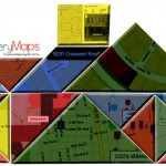
 This same feature can also be useful for potential homebuyers who would like to define a polygon on the map in which to search for properties. These search areas can be completely arbitrary and cross several neighborhoods and even towns. jQueryMaps swiftly calculates by latitude and longitude values, which properties fall within the designated area and displays these homes both on the map and in dynamic tables. See an example below created for RebateRentals.
Searching for a home within a particular neighborhood has never been easier thanks to our real-estate map tool that combines administrative polygon tools with OpenStreetMap. Contact us for more information and details.
Share the post "Real-Estate Maps created by combining jQueryMaps with OSM"