With summer upon us many are enthusiastically planning their summer vacations and retreats from the bustle of everyday life. We all cherish these moments to unwind, rest and reconnect with family and friends or even seek adventure. With this thought in mind, we wanted to share some projects that have benefited from a map of the US states within the tourism industry, applying many different types of cartography and software functionality. We will discuss some of the interesting developments that we encountered along our development path.
 Whether looking for leisure or adventure, placing information on a dynamic map as a useful visualization tool helps define what is available within a particular region and during a specific period. In this article we will discuss some important topics.
-
Reserve your Hotel with a Custom World Map Software
-
Arranging Flights on States Map
-
Mapping Tools to Locate Favorite Restaurants
-
Indoor Maps for Best Entertainment Experience
Use a World Map with Cities to Plan your Hotel Stay
 For high-end hotels individual locations can be define by star category on an exclusive World Map or for companies that only operate locally, on a map of the US States. The dynamic maps are often enhanced by filters that enable users to locate specific locations which include amenities important to the visitor, such as hotels that include fitness rooms, pools or spas. When a specific location is selected, details including images, links and videos can be dynamically populated within the pop-up boxes. More advanced features can also be added such as the ability to link to interior maps or street maps for each hotel. In addition neighborhood maps, including points of interest in the surrounding area can be developed for users to easily organize their activities while staying in the hotel. See example of a luxury hotel showing locations on a World Map created with system of filters:
DynamicMaps with Cities Help Plan your Flights
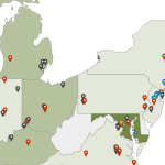
Finding the perfect flight to get you smoothly to your destination is an important consideration when planning your travels. To assist with this task, users can work with dynamic US States maps to see routes and end destinations for airlines. Maps can be highly configured to show information about city markers (such as price options or rating) and more details about the flight itself within a pop-up box whenever one of the lines are clicked or activated with a mouse hover. Projects can also show a default cartography initially, such as North America, but automatically expand to show the World if users access the page from an IP address outside of this region. This helps bring users the most accurate and relevant information. See an example of a map created for the airline industry. 
Location Maps for Finding Restaurants and Activities
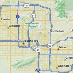
Once the hotel has been reserved, which usually involves the biggest consideration, comes the fun part of planning the activities during your vacation. Part of the endless summer fun include exciting meals, which can involve well-known chains or off the beaten path adventures. Using a dynamic map to locate restaurant chains is a helpful way to organize where to eat and even access the menu to plan what to eat through the same interface. Location maps can include multiple levels of navigation depending upon the expanse of the chain. At the top level, States where restaurants are located would be activated on a map of the US. By the same token cities in which the restaurant operate would be shown and active to be easily clicked for more details. At this point information can be presented to the user immediately in a pop-up box or the software can transition to street level detail for the city in which all of the options are conveniently plotted on the map. This provides users with reference to the area and nearby activities. More details including restaurant images, access to the menu, videos or special offers can be embedded within the pop-up boxes of the project. See an example of a shopping plaza map with search by restaurant or type.
Street Level Detail vs Area Based Mapping
![]() For showing activities, some clients may prefer to integrate street level detail as a way of guiding users to the specific address for each activity. This is the most common approach and we are all familiar with using a Google Maps application to locate a movie theatre or local cafe. However, when the activities are further spaced apart, for some clients, an area-based mapping view is more appealing as the look is simplified and avoids distracting users with unnecessary information. Additionally, street level detail for each location can be included in the pop-up boxes or once locations have been selected in the initial interface. See example of regional map with cities and locations.
For showing activities, some clients may prefer to integrate street level detail as a way of guiding users to the specific address for each activity. This is the most common approach and we are all familiar with using a Google Maps application to locate a movie theatre or local cafe. However, when the activities are further spaced apart, for some clients, an area-based mapping view is more appealing as the look is simplified and avoids distracting users with unnecessary information. Additionally, street level detail for each location can be included in the pop-up boxes or once locations have been selected in the initial interface. See example of regional map with cities and locations.
Indoor Mapping Software for Locating Stores
Inevitably with the joys of summer comes moments where tire of the unrelenting sun and less than comfortable summer heat. When in need a reprieve, going to a local mall or indoor shopping plaza is a great escape and can provides lots of entertainment options for the family. There are great solutions for locating information within any indoor space using custom interior mapping software. We discuss this in greater detail in a previous blog article.
 Searching for a specific store, entertainment facility of just finding your position within the building has never been easier. Users can either access the maps from the website using any mobile device or kiosks can be included in the building providing click and point navigation for the general public to use. The benefit of kiosks, is that the position of the map can shift based on each machine’s position within the mall. See online example of mall map software. For projects that would benefit from routing, perhaps in larger spaces or facilities with multiple floors, an algorithm can be added to the project to show the best walk able route from any two points in the building, including the option to follow the route with GPS enabled devices. See example.
The same features can also provide users all of the location capabilities to find seats in a stadium map, gaming floors in a casino map or the exact location of the roller coaster in your local amusement park.
No matter the variety of your summer adventures, we are certain that mapping will be a contributing factor to bring you closer to your destinations faster. Next time you are searching for a hotel, restaurant or location within a building with your family and friends, think of the ways that interactive maps can enhance your summer experience. Contact us to discuss any new project ideas that come from helpful R&R during your vacation.
Share the post "Interactive Map of the US States to Guide your Summer Travels"